


Customize
About Item
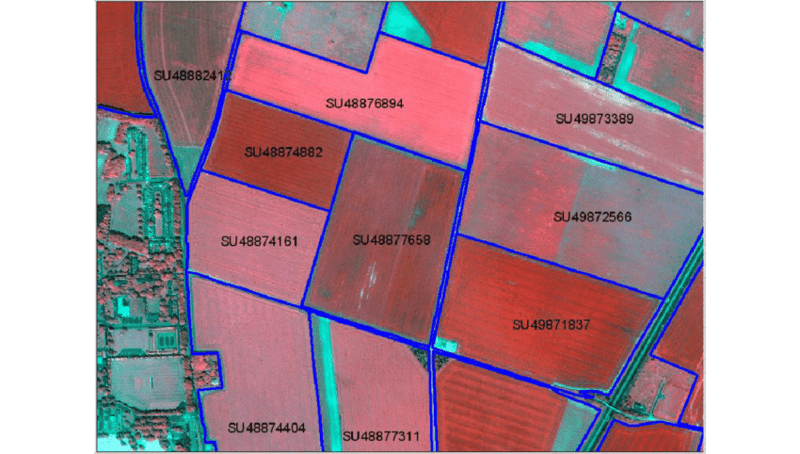
A GIS-based farm boundary and land parcel mapping system that digitally maps, geo-tags, and verifies agricultural land parcels using satellite imagery, GPS data, and geo-spatial analytics. Designed for FPOs, agri enterprises, financial institutions, insurers, and government agencies to ensure accurate land identification and monitoring.
Digital Farm Boundary Mapping for Transparent & Scalable Agri Management
Accurate land mapping is foundational to modern agricultural planning, credit disbursement, insurance validation, subsidy distribution, and precision farming initiatives. Manual land records are often outdated, inconsistent, or prone to dispute.
Our GIS-Based Farm Boundary & Land Parcel Mapping System enables precise digital mapping of agricultural plots using GPS-enabled mobile devices, high-resolution satellite imagery, and geo-spatial analytics.
The platform creates verified, geo-referenced digital farm records that enhance transparency, reduce disputes, and enable scalable farm monitoring.
Core Capabilities
The system provides:
GPS-based farm boundary mapping
Geo-tagged land parcel registration
Satellite imagery overlay
Acreage calculation and validation
Digital land ownership documentation upload
Multi-layer geo-spatial mapping
Crop type tagging
Historical land-use tracking
Land fragmentation analysis
Map-based reporting dashboard
Advanced Geo-Spatial Modules
1. Boundary Digitization Engine
Field boundary drawing tools
GPS coordinate capture
Automated acreage computation
2. Multi-Layer GIS Overlay
Soil type mapping
Irrigation infrastructure overlay
Climate and rainfall layer integration
3. Land Record Verification
Geo-referenced document storage
Digital KYC integration
Audit-ready documentation tracking
4. Change Detection Monitoring
Land-use change identification
Encroachment detection
Crop rotation tracking
Technology Framework
The platform integrates:
GIS mapping engine
GPS-enabled mobile app
High-resolution satellite imagery
Cloud-based geo-spatial data storage
Machine learning boundary validation models
API integration with land record databases
AI ensures boundary accuracy and detects inconsistencies.
Applications in Agri Sector
1. FPO & Farmer Networks
Farm aggregation mapping
Crop planning coordination
2. Agri Finance Institutions
Loan eligibility validation
Land collateral verification
3. Crop Insurance Companies
Accurate insured area mapping
Claim validation support
4. Government Agencies
Subsidy distribution planning
Land digitization initiatives
Strategic Benefits
Accurate land measurement
Reduced boundary disputes
Improved subsidy & loan transparency
Enhanced farm-level planning
Reliable geo-tagged farm database
Improved compliance & audit readiness
Deployment Options
SaaS GIS mapping dashboard
Mobile-based farm mapping app
Enterprise land record integration
API connectivity with agri platforms
Multi-region land analytics module
Suitable For
FPO clusters
Agri enterprises
Rural banks & NBFCs
Crop insurance providers
Government agriculture departments
Agri digital platforms